|
|
|
Atalante Geo-Trail
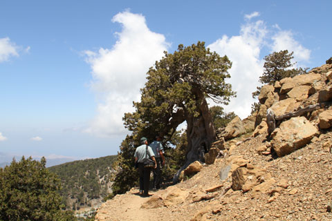
DESCRIPTION OF THE ROUTE The trail is named after the mythological Atalanta, a proud huntress and runner, protégée of the Goddess Artemis. The route circles around Mount Olympus (Chionistra) at a lower altitude than the Artemis Trail and passes through dense thickets of black pine (pinus nigra) and Troodos juniper. One of them is a huge 800-year-old juniper tree.
of the mountain range and characteristic rocks of the Troodos ophiolite complex. The trail does not feature any particularly difficult slopes but you need to take care because at certain points along the trail there are projecting stones. sticking out. You will enjoy a beautiful view in the direction of the villages of the Limassol, Paphos and Nicosia districts.
At a distance of 3km from the starting point there is a spring with drinking water and wooden benches to rest on. After 9km, the route reaches the main Troodos-Prodromos road. To continue, cross the main road and walk for about 200m on the Chromium Mine houses forest track in the direction of the church of Saint Nicholas of the Roof. There you will come across a wooden sign pointing out the direction of the trail which continues almost parallel to the main road to take you back to the Square. The trail is inside the Troodos National Forest Park which is a NATURA 2000 area.
GEOLOGY The main rocks in the broader area are harzburgite, in which small pods of dunite are found. Harzburgite belongs to the rocks of the Mantle sequence. It is truly impressive, not only from an aesthetic standpoint but also scientifically speaking, that walking on the highest point of the Troodos range is like walking on rocks belonging to the Earth’s Upper Mantle, which began forming at a depth of approximately 60km beneath the Tethys ocean floor some 92 million years ago. This is something that you will find in very few places around the world.
SERVICES In Troodos Square there are shops, restaurants, public toilets and hotels. Near the Square is the Environmental Information Centre, open daily to the public.
|
 On the trail you will find information signs about the plants, shrubs and trees
|